Introduction
What is a col or saddle in the context of mountaineering? Would you know what one looks like in real life? Do you know how a map depicts one and why it is so distinctive? Do you know when crossing one might be dangerous?
This article will answer these questions as well as explaining some other important characteristics of a col or saddle. Bizarrely, a popular, tasty snack might help to illustrate all of this more clearly. Read on to see why.

If you’d like to understand more, then our Hill and Mountain Skills Course, and our navigation courses, cover the use of map and compass, as well as GPS devices including mobile phones. The dates of forthcoming courses are in the Calendar.
Table of contents
Definition of a Col or Saddle
Col or Saddle
The word ‘col’ is originally a French word. We have imported it into the English language as a formal technical term in physical geography. A col is defined as the lowest point of a ridge between two peaks. The word ‘saddle’ in English describes the same feature in a less formal context, because of the resemblance to a horse’s saddle.
Some explanations of the terms try to distinguish between them, saying that a col only applies to higher mountains or steeper terrain such as in the Alps and a saddle is much more gentle. I believe this is a ‘made-up’ distinction that simply doesn’t exist – the highest roads in French-speaking parts of the Alps all go over the “Col de something.” So a col in France is not confined to inaccessible rocky features. It’s an everyday term describing more gentle terrain features too. As far as the purpose of this article is concerned, there is no difference between a col and a saddle other than the language from which the word is originally taken.
Pass
The term ‘Pass’ often crops up in this context too. A Pass (in English) is perhaps more of a human perspective on the physical feature. That is, if the col or saddle is a low point, then it is an obvious point for humans to make a route crossing the mountain ridge. Ancient farmers and traders first used cols (saddles) to provide them with the easiest way to ‘pass’ across the ridge. So, we call a frequently-used route a ‘Pass.’
So, I shall take it that a Col and a Saddle are physically the same thing. Very often a Pass will make use of a Col or Saddle (but not always). However, not all Cols or Saddles are used as Passes.
As a final aside, in German the word ‘Paß’ (Pass) is the standard translation for col, saddle or pass.
Gap
In the UK, in very rocky and technically difficult terrain, we often use the term ‘Gap’ to describe a very small, but locally significant feature. This sort of ‘gap’ may be too small to be depicted on most conventional maps, but that is only a question of scale. Choose a large enough scale (if one existed) and a ‘gap’ would be plain to see on the map. A ‘gap’ will not usually provide a ‘pass’ from one side of the ridge to another, but it is nevertheless an extreme sort of col.
Well known examples include Tower Gap on Tower Ridge, Ben Nevis; Crowberry Gap, which separates Crowberry Tower from the main face on Buachaille Etive Mor; and the ‘TD Gap’ on the Cuillin on Skye.
This is by no means definitive, however. Sometimes we use the word ‘gap’ in connection with any sort of col or saddle.
Physical Description of a Col or Saddle
A col (or saddle) is the lowest point of a ridge between two peaks. But at the same time it will also be the highest point between the ground on either side of the ridge. Most often, though not in every single case, a valley of some size, large or tiny, will run off from the col on each side of the ridge.
Let’s imagine a mountain ridge orientated North to South. We are on the North peak and wish to reach the South peak. First, we would set off walking from the North peak, heading south. Then we would descend into the col or saddle between the two and reach the lowest point, before the climb up to the South peak starts. Here, at the lowest point between the peaks, if we look to our left and right we are at the highest point between two valleys running away from the col. One valley would be running to the East and one running to the West.
The size and shape of these two potential valleys is infinitely variable – but they will be there. Sometimes the terrain is gentle and rolling, and the valley may be small, indistinct and very subtle. On other occasions it could be a steep sided gorge or a very prominent deep, steep-sided valley. They could be the same type on each side or the col, or be very different in appearance.
How The Pringle Helps
A few years ago, during a mountain navigation course, I was explaining to a client what is meant by a col or saddle. As I drew out the shape in the air with my hands, he chipped in saying ‘You mean it’s like a Pringle?’ I replied, ‘Yes, exactly like a Pringle’ and for the rest of that course every col was referred to as ‘a pringle’.
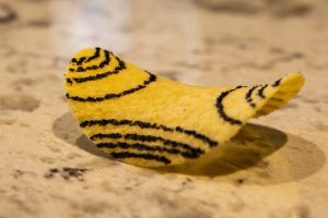
In the photo above, the Pringle shows imaginary contour lines. These form such a distinctive pattern that they are unmistakeable. Whenever you see this pattern, you know you should be looking for a col. Or whenever you stand at a col, this is what to look for to find your location on the map.
Five Components of a Col or Saddle on a Map
- Contour bends depicting the ridge descending from one of the peaks (on the left). The angle of the bend in the contours will vary from a gentle curve (as on the Pringle) to a sharp hairpin bend (where the ridge is narrow and pointed). Separately, the closeness of the contours will vary depending on the steepness of the ground.
- Contour bends depicting the ridge descending from the other peak (on the right). These may be very similar in pattern to the first peak – or completely different.
- Contour bends depicting the valley descending from one side of the col (visible in the photo above). Again, the angle of the bend will indicate whether the valley is a prominent shape, like below on the photo of Great Gable (with a sharp bend) or a more subtle depression, as on this Pringle. The closeness of the contours will indicate the steepness of the slope. In this case, the sides of the Pringle become increasingly steep.
- Contour bends depicting the valley on the other side of the col (out of sight in the photo above). They could be similar in shape or closeness to the first valley, or very different.
- Finally, and very importantly, what I call the ‘contour vacuum’. None of the previous four sets of contours touch at the col. They all head off in different directions. This leaves a ‘vacuum’ in the middle, denoting the flat space of the col or saddle itself. It could be a large, wide open area or a tiny spot, but the ‘vacuum’ will always be there if you look closely enough.
Importance of a Col or Saddle for Mountaineering
For mountain walking, hiking, or mountaineering it’s important to recognise a col or saddle on a map. Here are three reasons why:
1. To aid navigation
Very simply, a col or saddle is a very distinctive feature on the ground and it is equally distinctive on a map, when you know what to look for. So, once you understand this, it is immensely helpful to confirm your location. Even in terrain that has no other features, standing in a col or saddle is the navigational equivalent of standing next to an enormous landmark with neon lights on it.
2. Avoiding wind hazards
The wind will always be stronger in a col or saddle than in the surrounding terrain, usually including the summits above. This is because the wind is forced through a funnel and it must accelerate. Picture a gentle flowing stream, but with two large rocks in the middle. At the point that the stream runs between the rocks the flow of water will be much faster, until it calms down again on the other side.
On a day with a gentle breeze, therefore, you could expect the conditions in a col or saddle to be a bit more windy. It may not be a place to linger comfortably for lunch. But nor should it put you off continuing to your summit, if that is the plan. As soon as you climb up and out of the col, the wind speed will probably drop dramatically.
On a very windy day, however, when you are already struggling against the wind, a route which passes through a col may be a very bad choice. The faster wind speeds there may be too fierce to allow progress. It may be better to choose a route that avoids any cols or saddles if the consequence of being blown over are serious.
Finally, for the same reasons, choosing to camp in a col may not always be a good idea. Think carefully whether a different spot would be a better choice.
3. Avoiding avalanche hazards
In winter, a col or saddle may be the delineation between safe and dangerous terrain. Suppose the wind has been blowing up one of the valleys towards the col (at 90 degrees to the mountain ridge). Any falling or lying snow will be moved and deposited on the lee, or sheltered, side of the col. This wind-transported snow is likely to form the basis of a windslab avalanche.
Windward approach
Ascending to a col or saddle with the wind behind you means you are on the windward side of the col. Moving through the col from the windward side and descending the sheltered (leeward) side could be a fatal error. Sometimes, the difference between the two sides may be blindingly obvious. The windward side might be devoid of snow where it has been stripped but the leeward side will be covered in deep wind-blown snow. It may look inviting but is potentially lethal. At other times when everything is already covered in deep snow, this won’t be so obvious unless you are avalanche aware.
Leeward approach
By the same token, planning a route in winter which ascends to a col from the leeward side could be very dangerous. Walking into the wind, or into the direction where the wind has been blowing from recently, will take you onto the same avalanche-prone terrain as mentioned above.
Cols or Saddles in Other UK Languages
It is immensely helpful to understand the English meaning for some of the Welsh and Gaelic language words used on our UK maps. The Welsh word Bwlch and the Gaelic word Bealach are both usually translated as ‘pass’. But fundamentally this is because they pinpoint a col or a saddle.
As soon as you look at a map of Snowdonia (for example), or of one of the regions of the Highlands, and see either of these words then you know you are looking at a col.
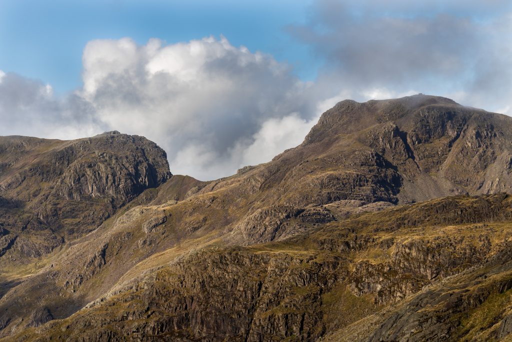
Examples of Cols or Saddles
Here are some examples of very different cols or saddles on famous UK mountains. The chances are that you have already been to some of these places.
The Harvey 1:25,000 Superwalker range of maps shown below make it easy to clearly identify the cols, especially as the terrain becomes more complex. These, and the sister range of 1:40,000 maps, are fantastic maps for outdoor pursuits. The map of Mickledore (below) is from the range of 1:12,500 Summit Maps which show an incredible amount of detail.


Summary
It is important for navigation to know what a col or saddle is, what it looks like and how map contours depict one. It is also important to understand the mountaineering significance of a col, particularly where wind and avalanche danger are concerned. Hopefully you now have a better idea.
The main points to remember are:
- A col or saddle will always have 4 sets of contour bends that don’t meet.
- There will always be a ‘contour vacuum’ on the map if the physical col is big enough to be shown on that map scale.
- Col = Saddle = Gap = Pringle
- Pass (most usually) = Pringle
- Bwlch (in Wales) = Pringle
- Bealach (in Scotland) = Pringle
- The wind will always accelerate through a col.
- A col could delineate safe terrain from dangerous avalanche terrain, depending on the recent weather conditions.
All maps reproduced by kind permission of HARVEY Maps.