Introduction
This ‘tips article’ will explain how to navigate off Ben Nevis summit. Or at least it will explain what is involved because an article like this can never replace proper hands-on learning and being well-practised. As well as explaining what you have to do to navigate off the summit of Ben Nevis, I’ll explain why it’s even relevant at all. Also, there a couple of tips on what to look out for to avoid making the most common (often fatal) errors.
There is a quick summary at the bottom of the page.
Our navigation and Mountain Skills Courses cover the use of map and compass, as well as GPS devices including mobile phones. The dates of forthcoming courses are in the Calendar.
Estimated reading time: 9 minutes

Navigating off Ben Nevis Summit – The Problem
Ben Nevis is the highest mountain in the UK, at 1345m. It is understandably a popular mountain to walk up and sees around 150,000 visitors each year. But of these, a handful will sadly die. The ordinary route up Ben Nevis, the ‘Mountain Path’ (also known as the ‘Pony Track’ and, misleadingly, the ‘Tourist Path’) is a technically easy path as these things go. Someone with a reasonable level of walking fitness should be able to ascend in 4-5 hours and descend in a further 2-3 hours.
Featureless Summit Plateau
The summit plateau area, however, is flat and featureless. The summit of Ben Nevis is in the clouds for around 300 days of the year. The weather you experience in Fort William will almost always worsen as you ascend and the prevailing weather in the UK can change quickly too. You should generally expect poor weather and limited visibility on the summit of Ben Nevis even in summer. In winter, a thick layer of snow and denser clouds will reduce visibility even more.
Cliffs on all Sides
At the summit of Ben Nevis, in almost all directions you are surrounded by cliffs and you may have to navigate a fine line between all these hazards to descend safely. In winter, cornices will conceal the edge of the cliffs and entrances to gullies and you need to stay well back from these. If you are not sure what this means, then a winter skills course is a great way of learning more.

Misunderstanding the GPS
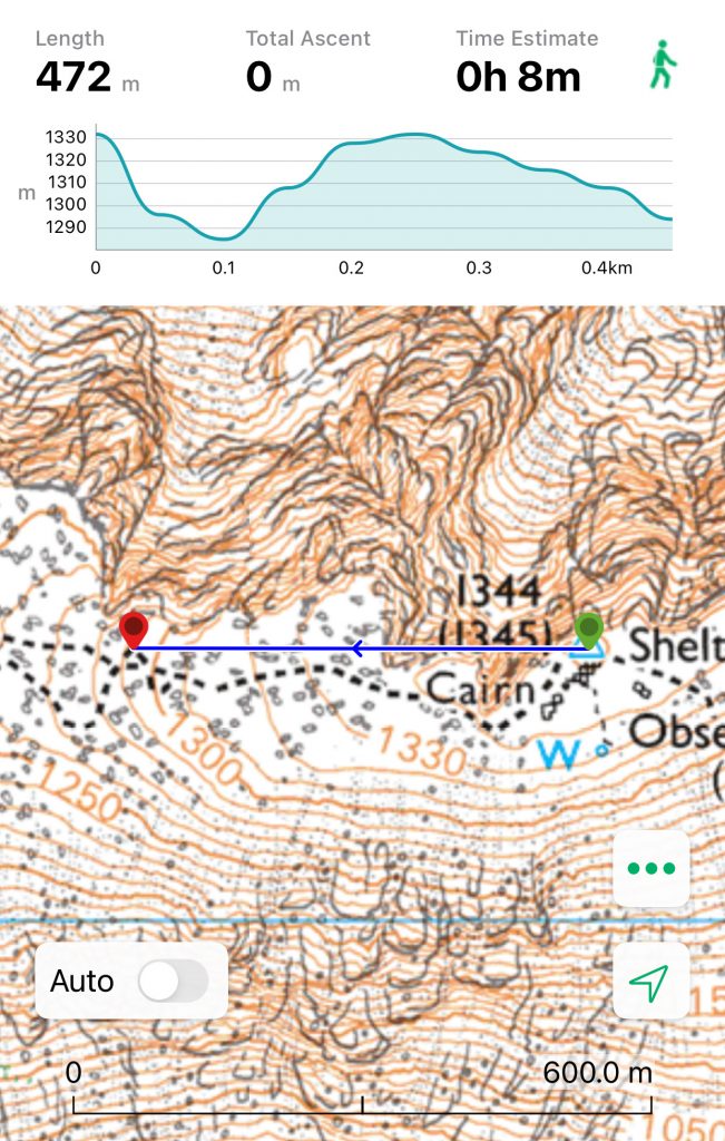
A GPS can help, but only if you already have a good understanding of maps and map-reading. If not, it can lead you badly astray. The photo below shows the line a GPS would point you along to reach a spot known as ‘McLean’s Steep’. This is a short steepening in the summit plateau area which you pass on the right way up or down. Unfortunately, the direct line from the summit to McLean’s Steep takes you right over the cliffs of the North Face, plunging into Gardyloo Gully. You can see what that looks like in the picture at the top of the page.

Navigating off Ben Nevis Summit – The Solution
There are a few different components to navigating off the summit of Ben Nevis. First of all, you should have the right equipment and the skills to use them. By all means carry a GPS or smartphone as these can be very useful additional tools. But it’s always the best thing to have a map and compass, and to know how to use them. Probably the best map to have is the incredibly detailed Harvey’s Ben Nevis Summit Map. That’s the map that you will see in most of these photos.
‘Dog-Leg’ Technique
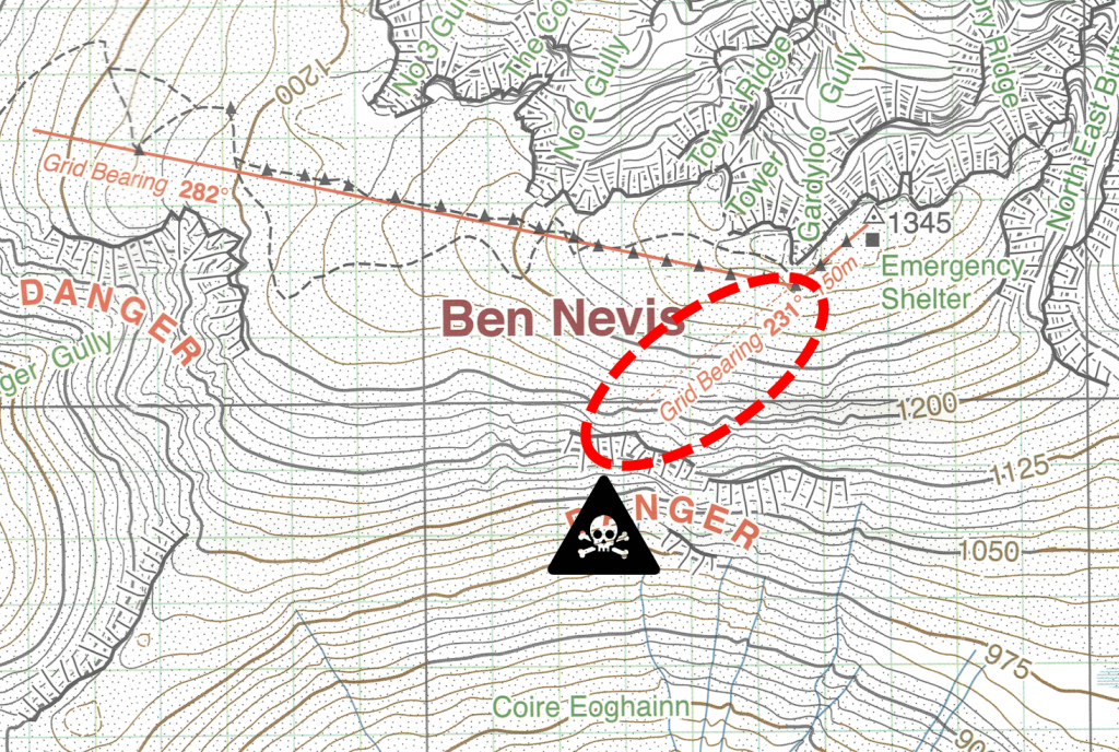
The navigational solution to getting off Ben Nevis is a technique called a ‘dog-leg’. This is a technique to avoid a particular point for any reason and deviate around it. In this case, navigating off Ben Nevis entails making a ‘dog-leg’ around the top of Gardyloo Gully.

This dog-leg involves first heading on a Grid Bearing of 231 degrees for 150 metres. Then, you switch and follow a Grid Bearing of 282 degrees until you find yourself well down the slopes and can pick up the ‘zig-zags’ once again.
Bearings and Distances
I’m not going to teach following a compass bearing in this article, so if you are not sure then it would be best to find out. You can read this article on how to use a compass or, of course, we cover this on our navigation courses. Similarly, I can’t teach everything about measuring distances in this article either. However, I can say that 150 metres will take most people 90-100 ‘double paces’. By this I mean if you set off walking with your left foot first, then when your right foot hits the ground you count ‘One’. Keep walking and counting up to 90 and you will be somewhere in the right area, 150 metres away. Learning how to measure distance by pacing is best learned on a course. But at the very least you can experiment and practice yourself before you have to do it ‘for real’.
Avoiding the Traps
There are three main traps when navigating off the summit of Ben Nevis. Gardyloo Gully, Coire Eoghainn and the notorious Five Finger Gully. These are all the scenes of deaths, accidents and Mountain Rescue call-outs because people have made navigational mistakes.
Trap 1 – Gardyloo Gully
The dog-leg tactic described above is all about avoiding Trap 1, Gardyloo Gully. If you move 150 metres on 231 degrees then you will successfully have avoided it.
Trap 2 – Coire Eoghainn
However, if you follow 231 degrees for too far, then you will end up in Trap 2, Coire Eoghainn. That’s why it’s vital to go only 150 metres. Look at the map below and study the contour lines.

You will see that the summit area is very flat because the contour lines are widely spaced apart. In fact, to go 150m from the summit on 231 degrees, you cross only an ‘auxiliary contour’ (dashed) and not even a main contour line. This means you should be walking on the flat. However, if you continue to walk along the 231 degree line, you will start to cross many more contours, and on the map they are closer and closer together. This indicates a significant descent that is becoming steeper and steeper. So, as you measure your 150 metres, be on the alert for the ground beginning to descend. If it does so, you have gone too far.
Hopefully you will have made the turn in the dog-leg correctly and now be heading on a Grid bearing of 282 degrees towards safety. As you move along, you will no doubt see lots of large marker cairns to show the right route, but you will also see various deviations in the path (in summer) or foot-steps in the snow (in winter).
Trap 3 – Five Finger Gully
In terms of pure navigation, blindly following foot-steps or alternative paths is never a good plan and almost always leads to getting confused. But from a practical perspective, especially in deep snow, it is obviously going to be physically easier to follow an existing trail. You just need to keep your eye on the navigation and make sure you know where they are heading.
There are splits and variations in the path which you are unlikely to have noticed on your way up, but which now give confusing choices in descent. As long as you are still heading in the direction of 282 degrees then all is well. But watch out for the scenario in the picture below. If you have inadvertently moved onto a more southerly path, then you will be heading towards Five Finger Gully. This path should veer back north again, but if you miss the bend then you will be at the top of the cliffs of Five Finger Gully before you know it.
During this leg of the journey, the key thing to remember is that if you have any sign of steep ground to your west, south-west or south – then you have strayed off route.

Navigating off Ben Nevis Summit – Summary
Navigating off the summit of Ben Nevis safely will make sure you don’t become one of the Mountain Rescue statistics. In summary, this is what you need to do:
- Be aware of the problem (which you already are if you have read this article) and/or book yourself onto a mountain navigation course.
- Don’t underestimate the difficulty of navigating off Ben Nevis if conditions are against you – and they very often will be, especially in winter. A winter skills course might be a good idea if you are unsure.
- Go prepared – take a map, a compass, have the knowledge of how to use them, and a take GPS if you like.
- Don’t follow your GPS blindly.
- Know how to set a bearing on your compass and follow it. First 231 degrees and then 282 degrees.
- Know how to measure 150 metres on the ground. Around 90-100 double-steps should be about right.
- Watch out for going further than 150 metres. Be alert for the ground dropping away. You should be on the flat for the first part of the dog-leg.
- Watch out for straying onto different paths. Make sure you stay on 282 degrees on the second part of the dog-leg. Any steep ground to your west or south is a bad sign.
- Once you are through the narrow ‘window’ between Five Finger Gully and No 3 Gully (to the north) then you should reach the relative safety of the main zig-zags on the Mountain Path.
All maps reproduced by kind permission of HARVEY Maps.


